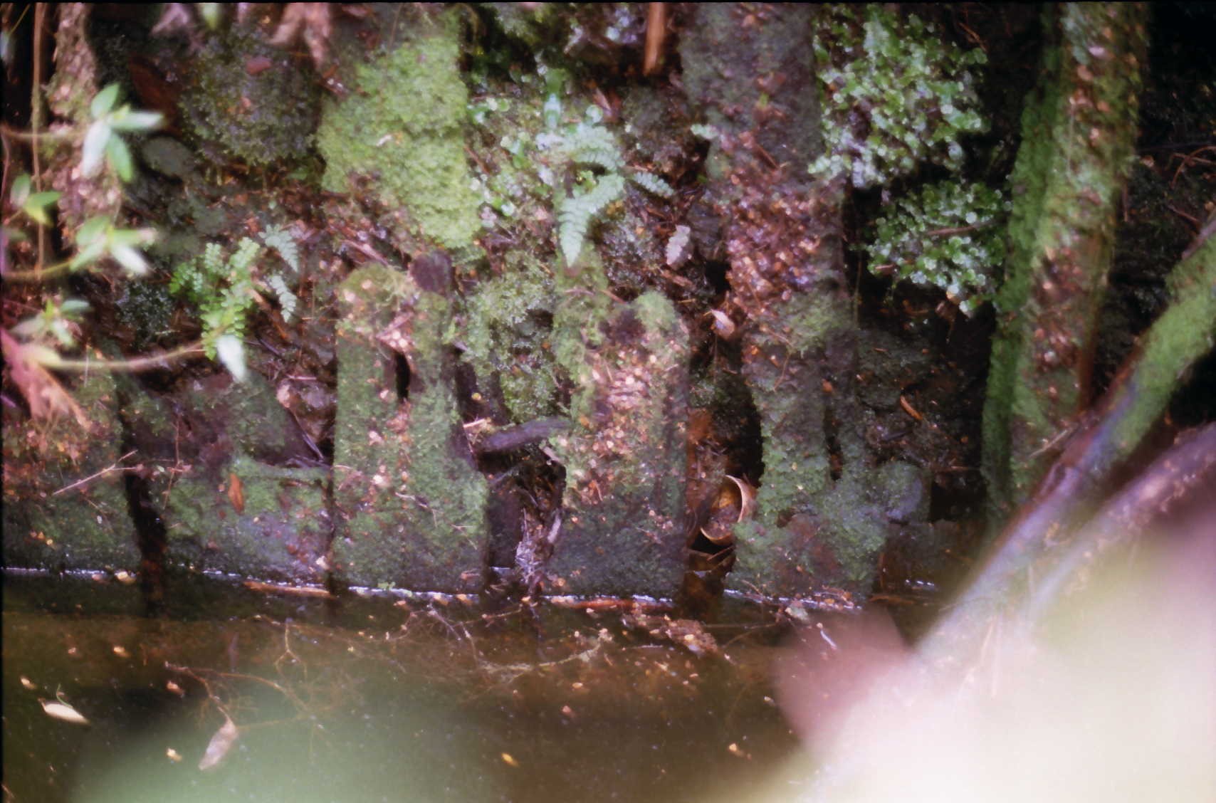
Recently a little piece of unexplained history solved itself. Decades ago, I saw a fern-shrouded water-filled hole in the bank of Douglas Creek near New Pelion Hut. It was full of small branches and leaf litter. However, boards around its square sides showed that it was not natural. It intrigued me and I wanted to know who had sunk it.

History
There was very little information about the shaft. Wal Connell, who guided and worked in the area since the 1930s, knew it but didn’t know who had made it.1 It must have been earlier than that.
Reports on the area by government geologists in 1893, 1901 and 1919 failed to mention it.2 Numerous mining leases had been taken over some of the Pelion Plains but none covered the area of the shaft. The focus had been further down Douglas Creek near Old Pelion Hut.
In 1959, a geologist, KL Burns, had a good look at the shaft. He described it as being just east of Pelion Chalet (an earlier version of New Pelion Hut) and being a timbered water-filled shaft. He emptied it to see the lowest levels of the strata of the Pelion area. He measured it as 75cm square and 7.5 m deep.3 But he didn’t say who had sunk it.
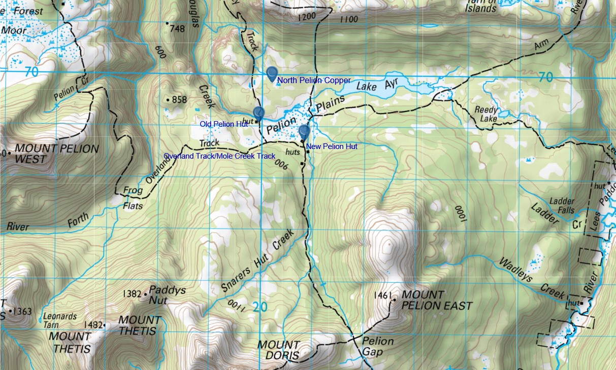
After a while, my best guess was that it was sunk in 1891 by the Mole Creek and Zeehan Mineral Prospecting and Exploration Company when they worked in the area. They were a well-resourced concern whose prospectors had ranged over the Pelion Plains. They camped in a railway survey hut that stood near the location of the future New Pelion Hut. They did take leases and sank a shaft north of, what was called at the time, the eastern branch of the Forth River. In early 1892, they left to turn their attention to an outcrop of coal near Barn Bluff.
I collated my notes and filed them. It was an intriguing little mystery that wasn’t going to be solved.
Much Later
More than twenty years later I was at Mineral Resources Tasmania looking for information on the Adamsfield Track with Nic. That involved going through the field books of government geologists. This also turned up one compiled by government geologist Alexander McIntosh Reid for his report on the Mount Pelion area prepared in 1919.4 It contained some interesting illustrations that caught my eye. It was part of a huge amount of information that I collected that day.
Even Later
Four years later I looked at the information collected that day more closely. The mystery was solved.
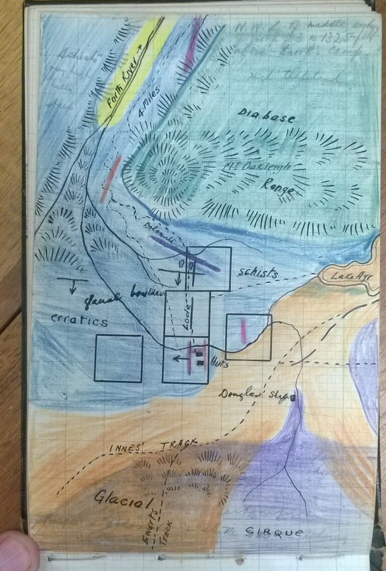
The huts in the sketch are the manager’s and workers’ huts at Old Pelion. Bushwalking and a hut at New Pelion were still years away. The position of ‘Douglas Shaft’ was exactly where it should be. Reid provided a description as well;
Douglas sank shaft on the left bank of Forth River in carbonaceous shale. He bored the ground first and struck a boulder containing chalcopyrite (a copper mineral). This enticed the prospector to sink a shaft.5
The identity of the prospector made sense since the stream bears his name. An early guide for the Overland Track suggested that it ‘may be named after W (William) Douglas who was lessee of a mining property’.6 This is officially confirmed by Placenames Tasmania.7
Those comments would not have solved the mystery as Douglas Creek also flows past the Old Pelion workings. But Alexander McIntosh Reid’s small note in the old field book from 1919 solved the mystery. That’s one small bit of lost history that has been brought back to light. It has taken more than 20 years to solve itself. There are still so many more.
Copyright Peter Brown 2023.
1 Wal Connell 1998, personal. communication
2 A Montgomery, Report on the country between Mole Creek and the Mount Dundas Silver Field and on the discovery of coal at Barn Bluff, Department of Mines Annual Report, 1893, Tasmanian Department of Mines: Hobart, Tas.
G Waller, Report on the mineral districts of Bell Mount, Dove River, Five Mile Rise, Mount Pelion and Barn Bluff, Secretary for Mines Annual Report, 1901, Department of Mines: Hobart, Tas.
Alexander McIntosh-Reid., The Mount Pelion Mineral district, Geological Survey Bulletin No. 30, 1919, Tasmania Department of Mines, Hobart.
3 KL Burns, The Permian stratigraphy of Douglas Creek, Pelion Range, Technical Report No.3, Tasmania Department of Mines, 1959, Hobart pp 60-67.
4 Alexander McIntosh-Reid., The Mount Pelion Mineral district, Geological Survey Bulletin No. 30, 1919, Tasmania Department of Mines, Hobart.
5 Alexander McIntosh Reid, Field Book AMR 6, 1919, Mineral Resources Tasmania.
6 Ian Boss-Walker, Peaks and High Places, 3rd Edition, Scenery Preservation Board, Hobart, 1964, page 62.
7 https://www.placenames.tas.gov.au/#p1