Waratah Dam has been getting a lot of press in the last few years. TasWater wants to drain it.1 They are worried that the dam wall will fail and flood Waratah. The local community wants the dam kept. They like it for fishing, as a tourist attraction, for its history and many other things.2
The dam, one of several, has been part of Waratah for a long time. It was built in 1911 as one of the last parts of the extensive system of dams and water races that supplied the Mount Bischoff mines.3 The wall did fail in May 1975 but it was rebuilt. In 2017, TasWater partially drained the dam.

Ian Hayes, Tim Jetson and I weren’t there for the dam. But we didn’t miss the chance to look at it and the nearby remains of the tramway to the Magnet mine. We were there to find a cart track that dated from the 1870s.
We were excited by a blog about the dray track which came with a map and photo of a small section found on the edge of Knole Plain.4 That was enough to have us hooked. But the chances of finding more of it weren’t good. There probably wasn’t much left. It had been a rough track that was cut through thick forest 140 years ago, abandoned soon after and some had been drowned by the dam. But the weather was nice, the scenery pleasant and the company engaging. There would have been worse things to be doing.

We started near the western side of the dam. The scrub was thick weedy regrowth and pretty difficult to get through. Further south we entered old myrtle forest. There was little understorey so it was easy going, other than to walk around or climb over the rotted carcasses of fallen trees. Moss covered the trees and the ground was coated in a carpet of myrtle leaves. It was a great place to be. We reached the western arm of the dam and walked through the gentle serenity of the forest. It seemed untouched. However, we had started to notice a few signs of logging but they were very old.
As usual, Ian spotted it. He had wondered off onto the grassy edge of the half empty reservoir. He called us over. ‘It’s old, look at the dowels’. We looked. It was a log; short, solid, axe cut on both ends and with two notches near each end and a hole in the middle of one notch. The other had the stub of a wooden dowel.
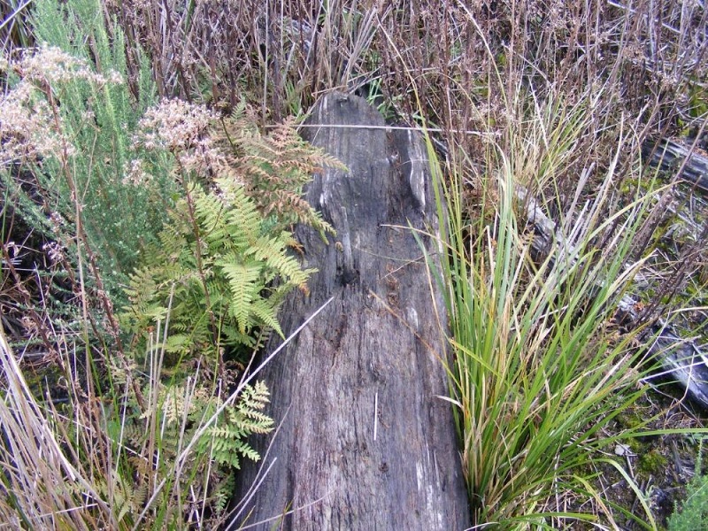
We looked out to the water. There was another similar log nearby. In fact, in amongst the debris of timber from fallen trees, there was a row of these short cut logs laying at the same angle on the same alignment. Other cut timber floated at odd angles nearby. And the now dead trees which studded with dam had been felled near the row of logs.
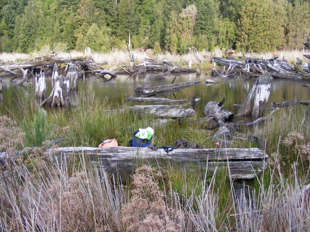
We seemed to be looking at the remains of the footings of an old bridge. It took a little to work out, the deck of the bridge was gone and some of the heavier sections had moved around a little. To add to the confusion, it was decorated with random debris from dead trees. A long log lay slightly adrift across the line of logs. It was probably a side log that had once sat in the notches of the footings. The smaller squared timber spiked to it had once held the deck in place.
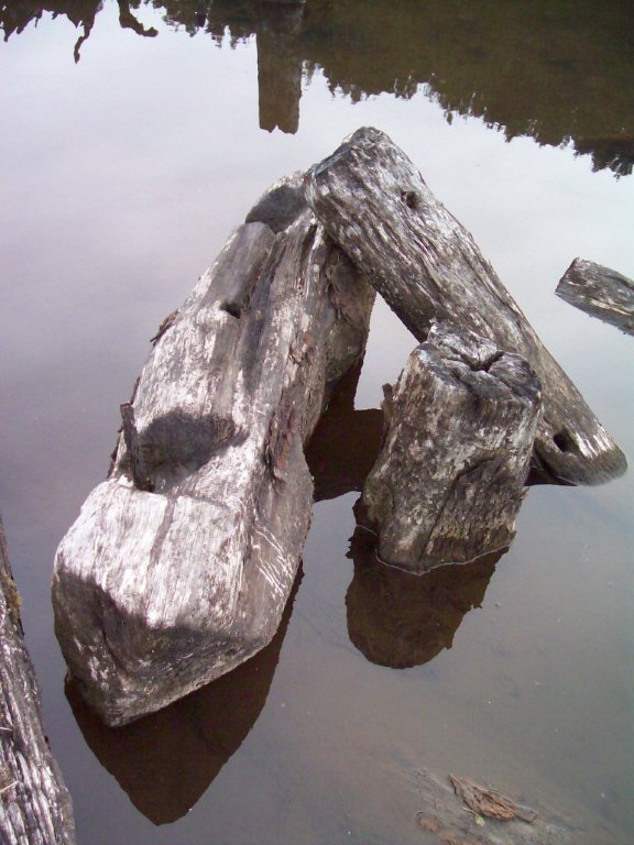
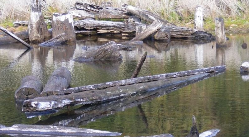
This very solid bridge could be part of the dray track. It looked old enough because of the way that it was built, particularly the axe cut construction and the dowels. A high water mark on some dead trees showed that the bridge had been submerged by the dam. That meant that it was built and used before 1911 when the dam was created.
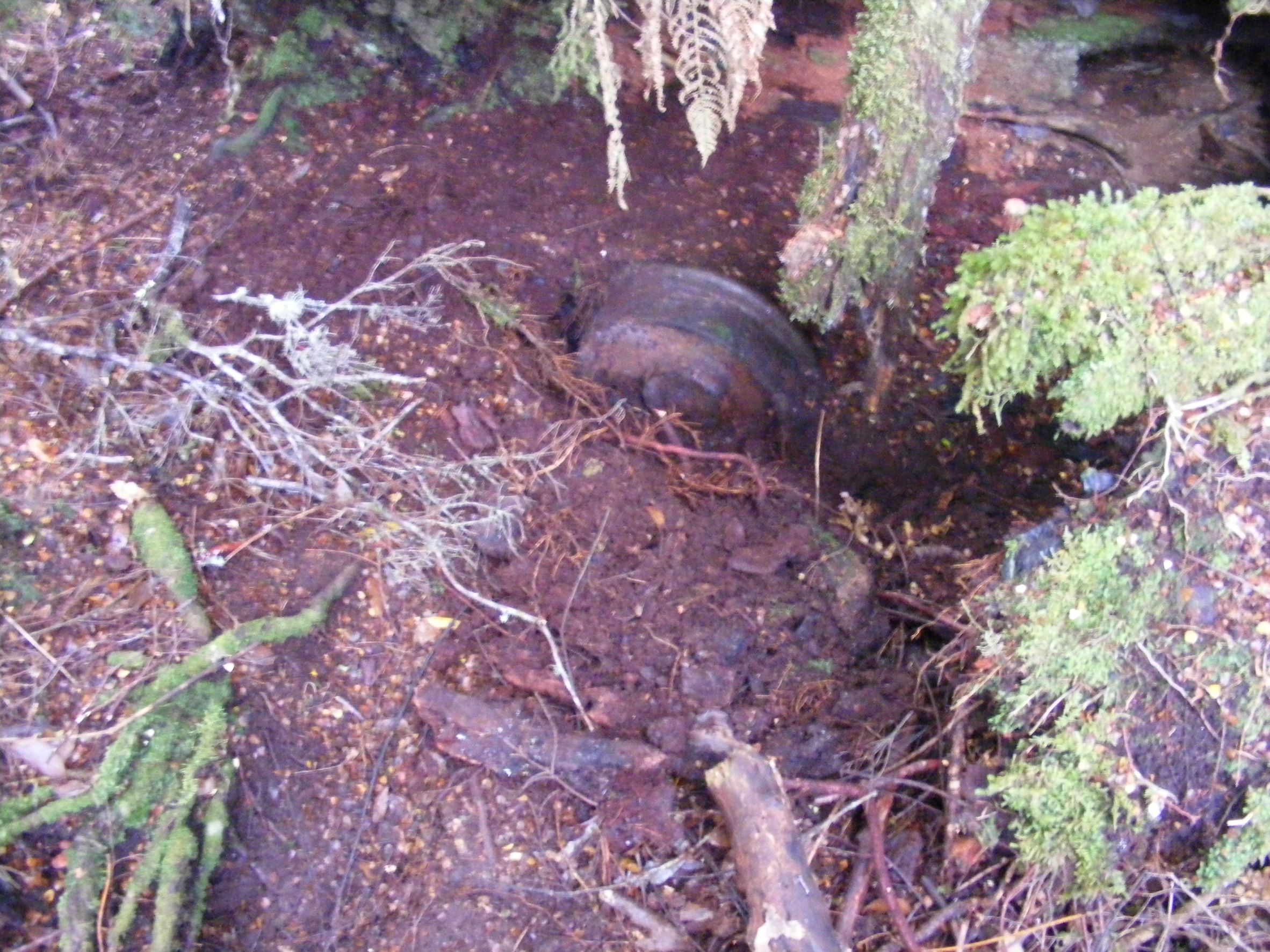
We needed to understand it more. They may be clues in the forest. We went to where we guessed that the alignment may have entered the forest. An essential clue was waiting. Tim managed to notice a well camouflaged shape just peeking out of the ground, a flanged wheel.
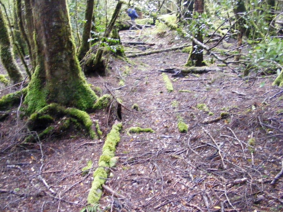
Now we knew that we were looking for a tramway; rails, spikes and sleepers. Ian just needed a faint scent. We had trouble keeping up with him as he followed the faintest possible indication of the tramway. A suggestion of pair of wooden rails here and there. The occasional iron spike still standing where the rails had rotted away. Despite massive trees growing through the alignment, we were able to follow it until all signs dissolved as it left the forest.
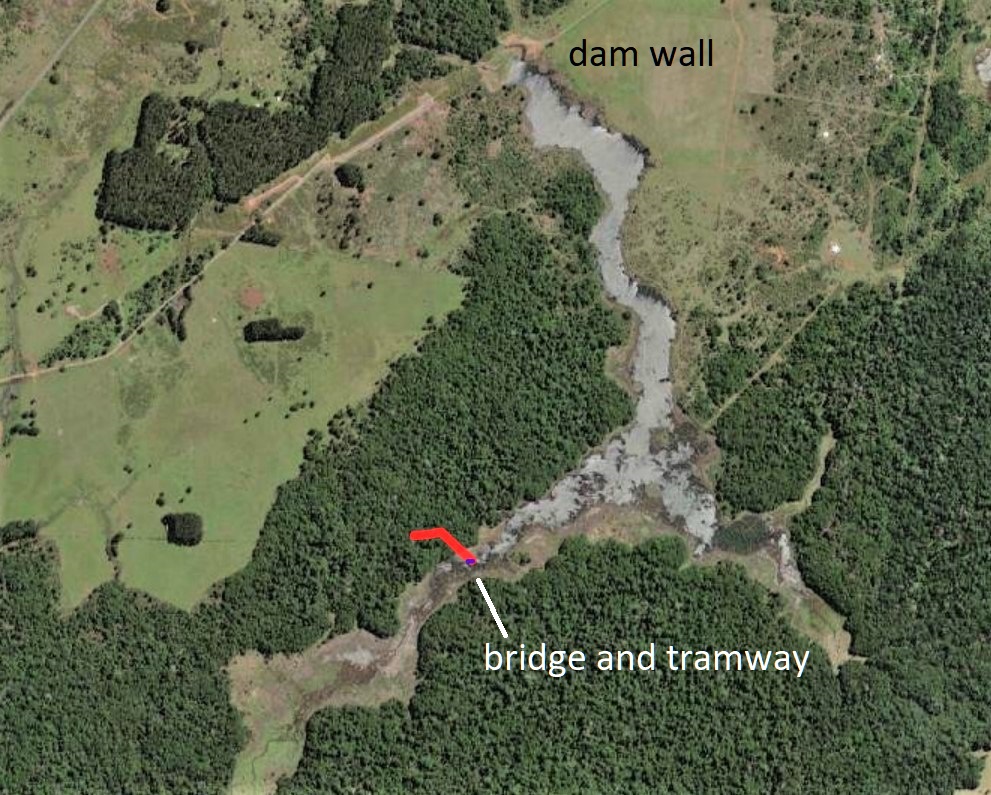
This tramway probably took timber to a saw mill. Could it have been built on the old dray track? It wasn’t. When we checked where it ran against the map we could see that it was quite a way west of the dray track.
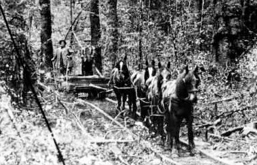
The timber tramway is one of those less exciting, but important, parts of the history of the Mount Bischoff mine. The Mount Bischoff company had timber reserves in the myrtle forests that stood around where the Waratah Reservoir lays. That the bridge survived at all was extraordinary.
Luck has helped save this fractured piece of history. Being flooded by the water of the Waratah Dam had preserved it, and hidden it too. It would have rotted away years ago otherwise. Partially draining the dam exposed it 110 years later. But now it will resume its decay. There may not be many years left for this old bridge.
Finding the bridge and tramway was unexpected and almost as good as finding the dray track. But would we give up the search for it?
Peter Brown 2021
1 https://www.taswater.com.au/yoursay/projects/all-projects/waratah-dam
2 https://www.change.org/p/premier-of-tasmania-save-the-waratah-dam; https://www.tasmaniantimes.com/2021/04/friends-of-waratah-reservoir-submit-appeal/; https://www.tasmaniantimes.com/2021/06/gimme-some-truth/; https://www.tasmaniantimes.com/2021/04/war-wyn-council-seeks-answers-from-taswater/;
https://www.abc.net.au/news/2021-04-11/last-ditch-bid-to-save-waratah-dam/100060718;
https://www.abc.net.au/news/2020-08-28/locals-still-angry-over-plans-to-drain-waratah-dam/12602922
3K Preston, Mount Bischoff Tin Mines: Pioneers of water power in the
Tasmanian mining industry, Journal of Australasian Mining History, Vol. 8, 2010, p 148 – 171
4 https://nichaygarth.com/index.php/tag/waratah/
5 https://nichaygarth.com/index.php/2020/10/03/the-roadrunner-william-byrne-mining-fields-mailman-part-one-the-mount-bischoff-mail/
A great article Peter, really interesting reading. Thankyou all
Thank you for your nice comments, Kathy
Very interesting Peter. Any idea of the gauge of that wooden tramway? It looks fairly narrow so I’m wondering if it was 2ft.? If so, it would be a bit narrow for a sawmill tramway (for carting logs to a mill, though some did). Maybe a firewood tramway?