The Number Plate Tree
We were looking for Damper Inn on the Gordon Track (read about that here). It turned out that knowing the location of the junction of the Gordon Track and the Port Davey Track would help us find the old hut. But the junction also had a history.
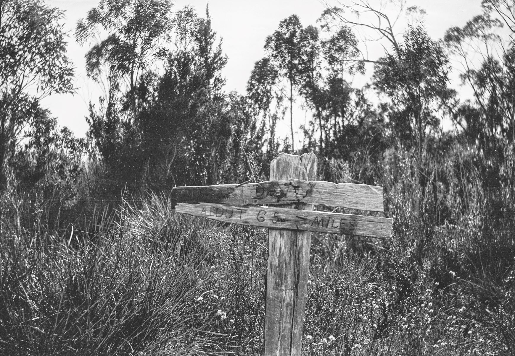
Originally it was marked by a wooden ‘finger post’ to direct travellers. Not that it always stopped some going the wrong way. One example was in 1899 when James Cooper lost his way under peculiar circumstances.1

Thinking about the junction of these two old tracks reminded me of a picture that I’d seen in a book more than thirty years ago. Written by R & K Gowlland, it was a lively history of the South-West called ‘Trampled Wilderness’.3 The picture showed a more elaborate sign post that had been made by the Hobart Walking Club. The number plates had been painted and punched with the destinations.
We looked for Damper Inn and found it with plenty of daylight left in the day. We knew roughly were the junction marker was so I suggested that we look for it.
Tim Jetson put the search like this.
We travelled to the west along Mueller Road, had lunch and then Ian and I became Nic for a short time – “you go and have a look Peter while we wait here” (this has become Nic’s favourite saying). Soon we drove up the road and found a stake by the roadside. On looking we saw tape and emerging from the ti-tree scrub was Peter confirming that this was indeed the Port Davey track. The other side of the road looked forbidding: thick shit. We started out as primitive man on all fours as it was easier than trying to be upright man.
I had looked on the northern side of the road where the junction should be. It was a wall of some of the thickest scrub that I’d ever seen. I told Tim and Ian that I’d lost my enthusiasm for the search. Ian hadn’t.
Ian asked how far to the junction. ‘About 10-20 metres’, I said. Instantly Ian responded that we can do it.
Ian led, we followed. Within a couple of metres, we were on hands and knees. We pushed, wiggled and slid along the ground, cursing Ian all the time. He kept going. About 15 metres later the baurea gave way to thick tea tree. At least we could stand up again.

Ian called out. We couldn’t see him even though he was only a few metres away. Tim and I worked our way towards his voice. Ian was looking at two bleached number plates laying on the ground.
This was the spot but nothing like it had once been. There was no stake, most of the plates had gone and the remaining two had no paint work. What was once a button grass plain was now a tea tree thicket.
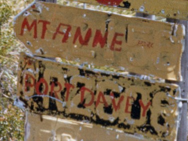
Later we matched the numbers of two plates with two in an old photo. The others have probably been souvenired and are nailed to a bushwalkers wall somewhere in Hobart.
On the way out we looked back on the day. We’d found Damper Inn and the junction marker on our first attempt. We still had plenty of daylight for the long drive home. We even had a little bit of fun at Ian’s expense comparing his picture with the number plates to a criminal’s mugshot. It had been a good day.
Copyright Peter Brown 2022
1 Tasmanian News, 30 Jun 1899, The wanders return.
2 Archives Tasmania – Junction of South Gordon Track and Marsden’s Port Davey Track – Peg reads Port Davey about 65 miles, 1941 Item number NS3195/2/2415
3 R & K Gowlland, Trampled Wilderness – the history of South West Tasmania, Richmond Printers, Devonport, 3rd edition, 1986
4 Janette Asche, https://www.flickr.com/photos/7272097@N08/4947177620