Another Heemskirk Adventure
Introduction
Like so many of our hunts, this one started with a photo. Nic had introduced us to Orient Mine near Trial Harbour. And what a story it had to tell. The team; Nic, Ian, Eddie, Jenny, Tim and I; visited it a few times looking at the remains of the mine: water races, alluvial workings and the machinery area. The most fascinating result was the discovery of the long-lost grave of Mrs Williams (read about that here and here).
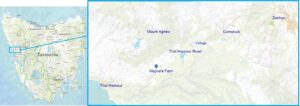
Orient Mine – Mayne’s Farm
The Orient had been the darling of the Heemskirk tin field in the early 1880s. A few tunnels and shafts cut a band of tin ore. In some kind of hysteria, the mine’s shareholders insisted that processing machinery be installed. Late in 1883, the first ore was crushed. The truth should have already been known. There wasn’t much tin. The mine closed and another boom at the Heemskirk field was over.1
In 1895, John Mayne took over the deserted buildings and cleared the forest to the south of the mine. He made a small productive farm on one of the few small pockets of good soil in the area.2 Prospectors and miners swarmed back to the area in 1902 when a rich lode of tin ore was accidentally discovered. Another boom started. Mining and prospecting have continued to ebb and flow in the area over the years.
That Photo
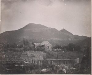
The mystery photo turned up during our adventures. We knew almost nothing about the it; who took it, or when, or even where it was. But it did bear the title ‘Mayne’s Farm perhaps Mount Agnew’. It was a great picture because it showed a house, its surroundings and some landmarks that would help locate it. We had got to know the general area pretty well so we hoped to find the house easily. We also had a great description of the farm that fuelled our imaginations.
In 1896, Mayne’s farm was described as almost a rural paradise on the harsh West Coast.
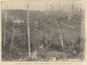
The old sheds (of the Orient Mine) have been transformed into a comfortable farmhouse, with a cosy flower garden in front – a touch of civilisation heartily appreciated when a visitor glances at the sombre forest surrounding the cleared ground. About 80 acres have been cleared and sown in English grasses, clover showing up in a big percentage. … Some two acres are bearing a heavy crop of potatoes, which with large beds of cabbage, peas, turnips, etc, the energetic proprietor hopes soon to place on the Zeehan market. The luxuriant growth of the grass has already attracted the attention of residents, and several local ‘neddies’ roam at will in the grass paddocks. Mr Mayne has about a dozen head of cattle.3
Even Mayne’s 11 children were ‘all specimens of the healthiest of healthy West Coast children’.
We also had another photo that showed the farm from a distance. Our guess was that the mystery photo was of a building at the top of the ridge in its background and was probably the old Orient Mine manager’s house.
The Search
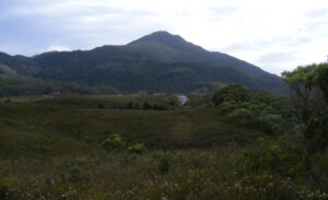
Naturally we wanted to find some signs of the house. But we gave up within a couple of minutes. One look at Mount Agnew showed its shape was nothing like that in the photo. Maybe it wasn’t even Mount Agnew. It could be any old hut in any part of Tasmania. That was that. Our shortest hunt and a failure. Everyone moved on to other things. Except for Ian. He said that ‘the farm house has hooked me good, no let up until I solve that one’.
Ian’s Obsession
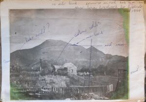
May wasn’t great outdoors weather but Ian made a series of long trips to the Trial Harbour Road west of Zeehan. With the photo in hand, and one eye on the shape of Mount Agnew he followed the road from Trial Harbour back towards Zeehan. It was quite a process.
At first, he ended up four kilometres east of the Orient Mine/Mayne’s Farm at the opposite end of Mount Agnew. There the mountain looked roughly right.
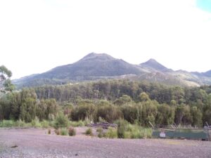
Now he started to work on getting the shape just right.
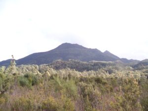
Once he had the background correct, he then moved on to get the foreground right.
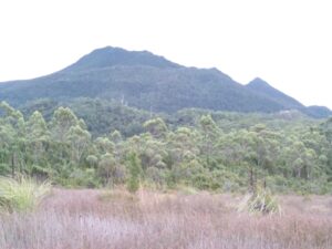
He was honing in on the location. But forests had grown up in the meantime making it hard to see everything at once.
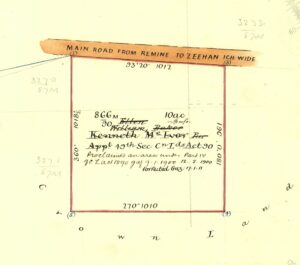
The change of the search area from the Orient Mine flushed out some historical information. There was an oddly small mineral lease nearby. It was in the name of Kenneth McIvor. The survey of his block noted that there was “Average land along road. Southern half rocky. Frontage under cultivation’. It had been a farm of some kind. The field work and written history were pointing to the same location. Exciting stuff.
A closer look at the old photo showed at least two large stumps. Their size suggested that they grew on a ridge rather than on the wet grassy flats where Ian had floundered about. He made another trip. There was a spot that matched the McIvor block. A track ran south from the main road which may have been original entrance to the land. Ian had also found the rocky ground on the Southern half and some prospector’s scratchings too. He was ‘very tempted to take another look tomorrow, it’s the fever you know.’
On 29 May 2023 Ian told the rest of the team that;
we are quite certain that we have now located the site. The rock (in the foreground in the picture) I think is the same, what you reckon? In addition, up on the rise through the regrowth there is a low chimney, even a ‘T’ hinge. You recall the odd panel in the fence nearer the photographer? We saw what may be a well or certainly a water hole that would fit nicely in that corner of the paddock.
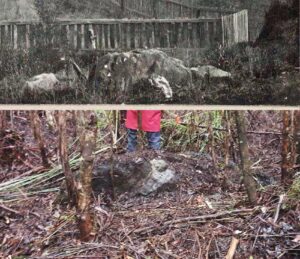
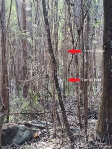
There certainly was a great result. Especially when the location was now so heavily overgrown. But there were a few loose ends.
The land had belonged to McIvor, and one other person. But we still didn’t know who built the hut in the photo and what was the story of this remote location? And not to forget the photo itself, who took it and when? Perhaps that is a story for another day.
Copyright Peter Brown 2024
1 Mercury, 4 December 1883.
2 Zeehan and Dundas Herald, 10 June 1895.
3 Zeehan and Dundas Herald, 28 January 1896.
Presumably McIvors Hill is named after Kenneth
Yes John, that’s what I understand too. Shame we could find a picture of him. He seemed a pretty interesting person.