A haven in the South West
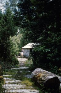
Again, a picture got Ian’s attention. It was a hut called Damper Inn and it was located somewhere in south-western Tasmania. The photo showed a neat corded track gently curved into the hut’s sunlit clearing. The hut looked like a welcoming haven in a dark forest.
A little research added some detail. It isn’t clear when the hut was built. However, the location had been a track-cutters camp when the Gordon Track was formed in 1899.2 It was 12 miles from the original start of the track at Tyenna, near Maydena. By 1919, the hut had been built and earned its title.3 Apparently Damper Inn was ‘damper in than out’.
From the 1930s, the hut sheltered pioneering bushwalkers who tramped used the Gordon and Port Davey Tracks to reach the beauties of the South-West wilderness like Mount Anne and Lake Pedder. Over the years, they photographed the hut’s decline and its exterior adornments.
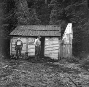
Despite its name the hut was appreciated by some walkers. At Christmas 1955, Keith Lancaster recorded;
Ah, welcome sanctuary from the cold and rain! We lit the fire, gathered wood and bedding, cooked, ate, dried out, and retired about 10 p.m. It was a cold night, but our worries of leaking tents and uncomfortable cooking were at an end.5

Later it fell into disrepair and recovered its wet reputation.
In the 1960s, the Hydro Electric Commission pushed roads into the South-West for its power schemes. Bushwalkers no longer needed the Gordon Track or Damper Inn.
Research
Ian’s interest was infectious. He, Nic, Tim Jetson, Richard Sands and I searched for information. Surveyor Richard identified the line of the Gordon Track from old aerial photos. Old maps showed the hut on the western side of a creek. Some named the stream the Weld River but others called it Black Creek, a tributary of the Weld. The elevation of the hut, reported as 1400 feet above sea level, was also a clue. The last hint was that it was 2 miles before the junction with the Port Davey Track. A place marked by a signpost.
That was enough information even though some clues contradicted others. We made some guesses and put a dot on our map where we would find the creek and then hopefully the track and finally the hut. However, in the back of our minds was a statement that Mueller Road had been built over the Gordon Track and the hut.
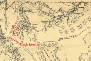
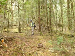
On 20 February, Tim, Ian and I found the creek. After only a few hours, we found the track. Would the track lead us on to the hut or disappear under the Mueller Road? Near a small creek were tell-tail little moss-covered bumps that suggested cording. Within 30 metres there was a small dark clearing and some sheets of tin.
The hut
The scene was more than we could have hoped for. Normally we are lucky if we see a few rocks that formed a chimney butt. Sometimes there are a few pieces of rotten timber that was once a hut’s walls or a vaguely square patch of vegetation that looks out of place.
This hut had slumped backwards to form a pile of timber capped by its roof of corrugated iron. It was in the right place for Damper Inn. Everything about it matched the old photos; the cording approach to a clearing (now over grown), the hut on the right-hand side of the clearing, the chimney on the right-hand end of the hut and the dimensions. The rotting timber was horizontal palings which also matched the photos.
The area was studded with artefacts. Stumps that supplied the timber for the hut or for the fireplace. There were rusting iron objects, broken crockery and broken bottles.
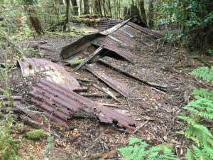
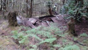
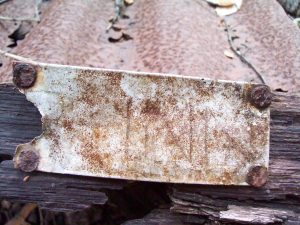
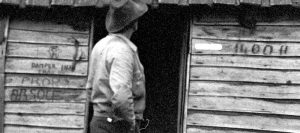
We were sure that it was Damper Inn and then we found a scrap of timber with a broken piece of metal plate nailed to it. A few letters were embossed into it- ‘R INN’. Looking back at the photos we could see a bright rectangle to the right of the door way which was obviously the plate. It would have read DAMPER INN. There was no doubt now.
The only surprise was the corrugated iron roof. All the photos showed a timber roof. The iron may have been added, with ridge capping, when the road and power lines created easier vehicular access in 1960s. It was possibly a shelter for the workers making Mueller Road and the power lines.
From haven to ruin
Damper Inn had been an attractive little hut that served prospectors, bushmen and bushwalkers for many decades. Despite its name, it had been a welcome sight. Now it is largely forgotten and rarely visited. Today it is a pretty ruin that is surrounded by artefacts that help tell the rich story of its long life.
Copyright – Peter Brown 2022
1 Janette Asche, https://www.flickr.com/photos/7272097@N08/4947177620
On the Gordon Track. My father and two friends, in December 1953, walked to the original Lake Pedder. They also climbed Mt Eliza and onto the Frankland Range.
2 4 Mar 1899. Mercury.
3 29 Jan 1919, The World, ‘The great south west’
4 Tasmanian Archives – Item NS3195/1/1186
5 http://dveltkamp.customer.netspace.net.au/KeithLancaster/130AroundPortDavey.htm
[6] https://commons.wikimedia.org/wiki/File:Damper_Inn_(than_out)_-_panoramio.jpg – Note that the photo has been reversed
7 Archives Tasmania, Exploration Chart 24 – Department of Mines sketch map of South West Tasmania from D’Entrecasteaux Channel to Point Hibbs, Item Number: AF395/1/37, 1942
The walkers in the photo by Jack Thwaites are Lindsay Whitham and Jock Turner I think. I have visited the hut a few times when it was still standing.
Thanks for your information Bob. It is great to hear from someone who has visited the hut. I hope that our blog did it justice, Peter